


ISS Transit Prediction
ISS Transit Prediction açıklaması
Bu uygulama Güneş, Ay ve Gezegenler için Uluslararası Uzay İstasyonu (ISS) Geçiş Tahminleri üretir.
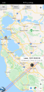
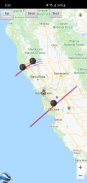
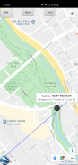
Kullanıcı enlem, boylam ve yüksekliği içeren bir konum belirler. Uygulama en son yörünge bilgilerini indirir. Uygulama, belirli bir uyarı yarıçapı içindeki her geçiş için tahmin yollarını içeren bir toplu taşıma tahmin haritası oluşturur.
Yalnızca Pro Sürümü: Birden fazla konumu belirtin ve kaydedin, Daha sonra görüntülemek için birden fazla tahmin haritasını kaydedin, Takvime geçiş ekleyin, Google Earth ile haritaları görüntüleyin, Kullanıcı tarafından belirlenen İki Çizgi Öğesi. Reklamsız.
Yalnızca Pro Sürümü: Uygulama içi satın alma mevcuttur: Ek Uyduların Kilidini Açın: Tiangong Uzay İstasyonu ve Hubble Uzay Teleskobu da dahil olmak üzere herhangi bir uydu için geçişleri hesaplayın.
KULLANICI ARAYÜZÜ
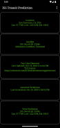
Ana ekranda 5 düğme bulunur:
•Konum - Tahmin oluşturma konumunu eklemek veya seçmek için bu düğmeye basın
• Uydu - Aktarım uydusunu değiştirmek için bu düğmeye basın (Yalnızca Pro Sürüm, Uygulama içi satın alma gerekir)
•İki Çizgi Elemanı (TLE) - Yörünge elemanlarını indirmek için bu düğmeye basın
• Tahmin Oluştur - Tahmin oluşturmayı başlatmak için bu düğmeye basın
• Tahmini Görüntüle - Tahmin haritasını veya metin dosyasını görüntülemek için bu düğmeye basın
Seçenekler menüsü aşağıdakileri sağlar:
•Konumlar - Kayıtlı konumları eklemek, seçmek, düzenlemek veya silmek için basın (Yalnızca Pro Sürüm)
•Tahminler - Kaydedilmiş tahmin haritalarını görüntülemek, paylaşmak veya silmek için basın (Yalnızca Pro Sürüm)
•Ayarlar - Kullanıcı tercihlerini ayarlamak için basın
•DEM Dosyaları - İndirilen Dijital Yükseklik Modeli (DEM) Verilerini listelemek veya silmek için basın
•Yardım - Bu yardım sayfasını görüntülemek için basın
•Hakkında - Uygulama sürümünü, kredileri ve bağlantıları görüntülemek için basın
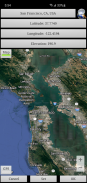
YERLER
Ana ekrandan erişilebilen "Konum" düğmesini tıklayarak adlandırılmış bir gözlem konumu ekleyin.
Konum koordinatları şu yöntemlerden herhangi birine girilebilir:
•Manuel - Metin kutularına enlem, boylam ve yüksekliği girin. Pozitif değerler Kuzey ve Doğu'yu, negatif değerler ise Güney ve Batı'yı temsil eder. Yükseklik, mevcut tahmin birimleri ayarına bağlı olarak deniz seviyesinden metre veya fit olarak girilebilir.
•Ara - Bir konumu aramak için arama düğmesine basın.
• Harita Girişi - Bir konumu yakınlaştırmak ve kaydırmak için haritayı kullanın. Ayarla düğmesine basıldığında metin kutularındaki konum adı, koordinatlar ve yükseklik ayarlanır. Geçerli koordinatların yüksekliği, belirtilen yükseklik veri kaynağı ayarı kullanılarak alınır. Harita/Sat düğmesini değiştirerek harita ve uydu modları arasında geçiş yapın.
•GPS - GPS düğmesine bastığınızda, uygulama konum koordinatlarını ve yüksekliği elde etmek için GPS'i kullanır.
Kaydedilen konumları düzenlemek ve silmek için seçenekler menüsünden erişilebilen konumlar sayfasını kullanın. (Yalnızca Pro Sürümü)
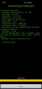
TAHMİNLER OLUŞTURMA
Bir konum girildikten ve TLE indirildikten sonra, tahmin oluşturmaya başlamak için "Tahmin Oluştur" düğmesine basın. İlerleme çubuğu, işlemin tamamlanmasının ne kadar süreceğine dair bir gösterge verir. İşlemci hızınıza bağlı olarak tahminlerin oluşturulması birkaç dakika sürebilir. İptal düğmesine basıldığında tahmin iptal edilir.
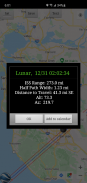
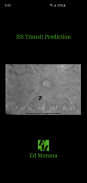
TAHMİNLERİ GÖRÜNTÜLEME
Tahmin oluşturma işlemi tamamlandıktan sonra tahmin haritası veya metin dosyası görüntülenebilir. Tahmini Görüntüle düğmesine basmak, önceden oluşturulmuş tahmin haritasını getirir. Harita görünümündeki metin düğmesi tahmin metnini görüntüler. Harita/Sat düğmesi Harita modu ile Uydu modu arasında geçiş yapar.
Haritayı Google Earth'te görüntülemek için harita görünümünde Google Earth düğmesine basın (Yalnızca Pro Sürüm). Tahmini daha sonra görüntülemek üzere kaydetmek için kaydet düğmesine basın (Yalnızca Pro Sürüm).
Bir takvim etkinliği oluşturmak için toplu taşıma bilgileri penceresinde takvime ekle düğmesine basın (Yalnızca Pro Sürüm).
Önceden kaydedilmiş tahmin haritalarını görüntülemek, paylaşmak ve silmek için seçenekler menüsünden erişilebilen tahminler sayfasını kullanın (Yalnızca Pro Sürüm).
İZİNLER
Konum: Yalnızca konum girişi sırasında GPS seçeneği seçilmişse gereklidir
ISS Transit Prediction - APK Bilgisi
APK sürümü: 3.1.1Paket: com.ed_morana.iss_transit_prediction_freeISS Transit Prediction uygulamasının en son sürümü
Diğer sürümler


Aynı kategorideki uygulamalar

 4.383.783.43
Hoşuna gidebilecekler...


